
GPS basics
by Don Caswell
Hunter 3
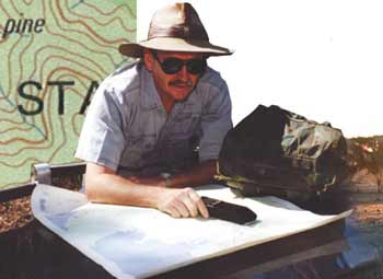 The GPS is a confidence-building device like no other. Those of us
who love the outdoors now have a remarkable navigational tool that can
expand our horizons. However, some GPS owners are a little daunted by
the gadget’s wide range of advanced features and fail to extract the
GPS’s full value. Don Caswell reckons if you master a few GPS basics then the more advanced features will fall easily into place.
The GPS is a confidence-building device like no other. Those of us
who love the outdoors now have a remarkable navigational tool that can
expand our horizons. However, some GPS owners are a little daunted by
the gadget’s wide range of advanced features and fail to extract the
GPS’s full value. Don Caswell reckons if you master a few GPS basics then the more advanced features will fall easily into place.
Most taxis and delivery trucks now operate more efficiently thanks to GPS management systems. Top-end family sedans and 4WDs now feature factory-fitted GPS navigation and this will soon flow onto all models. Within a decade a built-in GPS navigator will be as standard as a dashboard radio. Already just about every boat that puts to sea, from the smallest runabout and up, now carries a GPS.
While more and more 4WD owners are using GPS units, the adoption rate still seems to be well short of that in boats. Land navigation is certainly a little easier than navigation at sea. Nevertheless, I find my dash-mounted GPS invaluable. Whether exploring western grazing properties of the vast untouched wilderness of Arnhem Land, the directions of the landowners can be vague at best.
Paddocks or areas are often referred to with descriptions that were developed in grandpa’s day or even earlier. The ‘red gate’ that you drive 30 kilometres on a little-used track to find may well have had the last atom of red paint blown off it 40 years ago and now is no different to the other rusty gates in the area.
A vehicle-mounted GPS can rapidly solve these sorts of problems by allowing you to explore the obscure corners of our country, either night or day, confident in your ability to know exactly where you are.
The real payout with a GPS unit, however, is that it will allow you to become a participant rather than a vehicle-borne spectator. The greatest value of the GPS is realised when you get out of your vehicle and head bush on foot. Whether this is to enjoy a hike and secluded picnic with your family or to make the transition from being a shooter to become a hunter, or both, the options and rewards are yours for the taking.
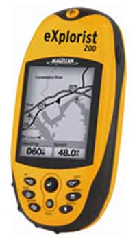
There is a wealth of information available on the GPS system and its use. GPS units come with comprehensive user manuals, there are stacks of web sites (see fact box) and quite a few publications on the subject. GPS units themselves offer a great array of features and options. In fact, I am sure that some people might be disconcerted because there may be too much information to assimilate.
I think there is probably a good analogy to video recorders. VCRs can be programmed to do many things, like record a range of selected shows, on different channels and times, but few of us ever use more than the play feature and we rarely even correct the VCR clock. There is a lot of stuff that the average user does not really need to know. Similarly with the GPS, you need to be familiar with the basic operation before you get too concerned with the many advanced features.
 The Basics
The most basic requirement is that the GPS can tell you where you are
and that you have confidence that it has done so accurately. Unless
that is so, then the wealth of advanced features on your unit are
useless. The other essential is being able to relate the GPS data to a
map of the area you are in.
When you first switch on your GPS unit it will immediately begin searching the sky for satellite signals. If the GPS memory has been cleared, either deliberately or accidentally, or you have moved more than 480 kilometres since the device was last switched on, then the GPS will need to initialise. It can do this automatically itself, but this can take as much as ten minutes. You can hasten the process considerably by manually entering your approximate location, date and time. Your user manual will tell you how to do this for your particular unit. If you haven’t cleared the memory or moved more than 480 kilometres with the unit switched off, it will locate the required number of satellites and should lock on within a few minutes.
It is essential that you learn the key status icons for your particular GPS unit. These vary from model to model. The GPS unit will have four basic states after you switch it on. In order it will:
- Begin searching for satellites
- Begin acquiring satellite signals
- Lock onto the required number of satellites - but the satellite geometry or signal quality is poor
- Lock onto the required number of satellites with good satellite geometry and signal quality
In cases 1 and 2, the GPS will not know where it is. Some units may display the last known position fix, which could be significantly different from where you now are. Some GPS units will issue a warning. In case 3, the GPS unit will have a reasonable idea where it is within a few hundred metres. In case 4 it will, in most instances, give you a position that is within ten metres of the true location. Obviously, it is important to know that your GPS has locked onto good signals and the position fix displayed is correct.
If the GPS unit does not move from condition 3 to condition 4, then you may have to physically move a little distance, say five or ten metres. Heavy timber, uneven terrain, buildings or nearby structures could be blocking out a sizable portion of the available satellite signals.
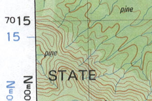
Once you are confident that the GPS is accurately fixing the location, then you refer to the map of the area. To make the most of a GPS you need a map. The other basic essential for using your GPS is to know how to select the reference system that matches your map. For land navigation, topographical maps use a UTM grid reference based conveniently on one kilometre squares. Nautical maps use latitude and longitude.
You will need to become familiar with transferring GPS readings to your map. The otherwise abstract sequence of numbers displayed on GPS screens do not convey any real sense of where you are until that position is transferred to the map. As a check, confirm that prominent features indicated on the map can be seen, such as a hill to the south-east, a road or river to the west, etc. A good practice is to orientate your map so that the top of the map (north by convention) actually points north. This makes landmark recognition and route selection easier.
Once you can do these relatively simple things, you have extracted 90 per cent of the real value that the GPS has to offer. All the other features are finesse, but of no value unless you have mastered these basics.
 Putting it into practice
Apart from having a topographical map for the area you are in, it also
pays to sketch your own simple maps as you go. I keep one of those red,
hard-covered accounting journals in the car door pocket. It is a robust
logbook that can take the abuse of fieldwork without falling to bits.
When driving through new country I sketch landmarks as I go. The tap of
a button will save the location to the GPS memory for later retrieval,
but it is worth taking the trouble to write the location and waypoint
number on your hand-drawn map too. At the same time, note how many
kilometres you have travelled from the last checkpoint and roughly in
what direction.
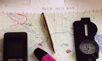
When on foot I carry a topographical map of the area, a pocket notebook and pen, a set of spare batteries and a compass. Before leaving the vehicle in unfamiliar country I make sure I have both written its location co-ordinates in my notebook and stored the position as a waypoint in the GPS, even for the shortest trip. I also slip on a small shoulder bag with two litres of water, a space blanket, a mini first-aid kit, a box of matches and a mini-mag light. Sometimes companions have chuckled, “Don, we are not going far and are not planning on getting lost.”
Well, exactly. I don’t believe anyone ever plans on getting lost. Like all the best advice on good practice, most people do not appreciate it, or adopt it, until after they have had a hard lesson. And on that note remember that you should never rely totally on your GPS for navigation, no matter how tempting it may be to do so.
The Absolute Basics - using a GPS
Even if you never learn any other operational features of your GPS you
should make a point of being familiar with the following:
- The screen icons that let you know that the displayed positional fix is accurate (locked on with a good signal), approximate (locked on with a poor signal) or unreliable (searching or acquiring satellite signals).
- How to select the co-ordinate system, LAT/LON for nautical maps, UTM for topographical land maps.
- You must also have a map of the area you intend navigating over and you should be familiar with the grid reference system on the map and know how to translate the GPS position data to a point on the map. Practise this in your back yard, local parks and suburban streets before you head bush.
Don’t even bother with all the other features your GPS has to offer until you are completely familiar with these basics. Once you have mastered them everything else will follow.
Never rely solely on your GPS. Use the conventional skills of navigation, such as compass bearings, distance travelled, landmarks and dead reckoning, then with the GPS as an augment you will become a confident and proficient navigator.
 Going Beyond Basics - Choice of Datum
The next important step in going beyond basics is to appreciate the
difference that choice of datum has. Let it be said that a novice
should be able to navigate quite adequately without bothering to know
anything about choice of datum. However, if you want to make maximum
use of your GPS and topographical map, the first step on that path is
understanding choice of datum. The following scenario is illustrative.
You and your buddy have identical GPS units. You go on a little jaunt, a hike up the double peaked Mount McConnel (see map on page 84). It is a pretty simple navigation exercise. You leave the vehicle on a logging road and hike up the spur towards the peaks. It doesn’t take too long to get to what you think is the first peak and you both decide to check the position with your GPS units.
Strangely, you have different positions indicated even though both receivers are side-by-side and locked on. According to your buddy’s GPS you are smack on the 477 metre peak, as your observations of the terrain indicate. Your own GPS, however, reckons that you are a third the way down the side of the mountain on what is a pretty steep slope, about 200 metres to the NNE of where you know you really are.
Your GPS displays 01 451223E, 7013991N.
Your buddy’s GPS displays 01 451182E, 7013786N.
Before you get cranky with your GPS have a closer look at the displays. There is something different between them, apart from the position anomaly. Yours has the cryptic ‘WGS84’ whereas your buddy’s GPS displays ‘AUS84’. This refers to the datum system that the unit is using to interpret the satellite signals. GPS units by default use WGS84 because it is the world grid reference system.
If you read the small print on the bottom of your topographical map, underneath the scale bar, you will find the horizontal datum used in constructing the map. In most cases it will be either Australian Geodetic Datum 1966 or 1984. These relate to the optional datum choices AUS66 and AUS84 in your GPS unit. There is only a slight difference of a metre or two between these two datums. However, as shown, there is a much bigger difference between the AUS datum and WGS84, which is about 200 metres.
A feature of recent topographical map reprints is that the WGS datum is shown around the border in blue, alongside the AUS datum (refer to map on page 84). Older topographical maps show only the standard AUS datum grid. As you will note, the topographical map grid is to the AUS datum and you would be wise to select the AUS84 datum as the option in your GPS.